Donald Trump wants to build a wall along the border between the United States and Mexico. He has made this sentiment clear since the very earliest days of his Presidential campaign. He has been mocked, scorned and verbally pilliored in every imaginable way. He has been called a racist and a xenophobe and worse.
But he’s not wrong, and here’s why:
The border between the U.S. and Mexico runs from the Gulf of Mexico to the Pacific Ocean, a distance of 1989 miles. The border touches four states; California, Arizona, New Mexico and Texas. There are forty-eight (48) authorized border crossings. It is the most frequently crossed international border in the world, with over 350 million legal crossings annually.
No one really knows how many illegal border crossings there are each year. In 2016, the U.S. Border Patrol reported 408,870 apprehensions of illegals crossing the border with Mexico. As part of these apprehensions, they seized almost 1.3 million pounds of marijuana and over 5000 pounds of cocaine. (7)
Critics of Trump’s plan focus on social and economic aspects of illegal immigration. Most discussions are about jobs and fairness and being welcoming to migrants and refugees. One thing the critics rarely talk about is:
The Drugs
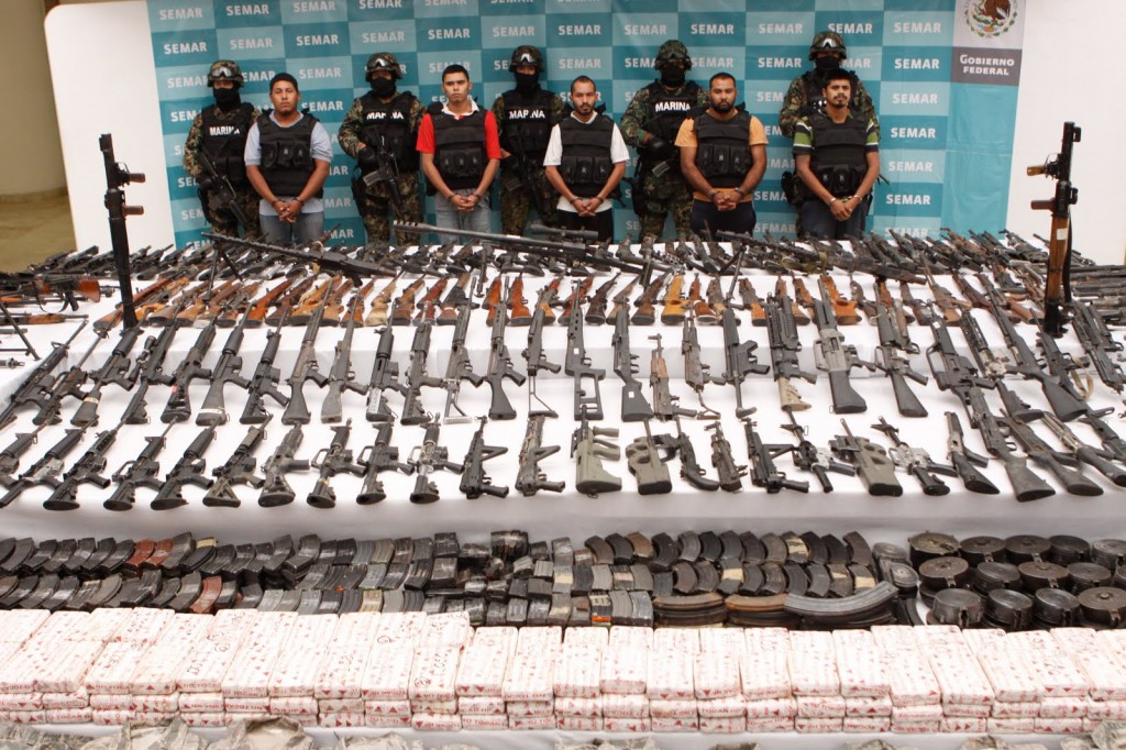
Drug cartels from Mexico and Central America ship their drugs into the United States across the Mexican/US border. Estimates of the value of these drugs crossing the border each year range from $10 billion to $50 billion dollars. No one actually knows the true amount, and $30 billion dollars is considered a conservative estimate. Mexico is the number one foreign supplier of marijuana into the United States. Mexico is the number one foreign supplier of methamphetamine into the United States. Mexico is a major supplier of heroin into the United States. Mexico is a major transportation corridor for cocaine into the United States.
The illegal drugs imported into the United States cost taxpayers between $200-$300 billion dollars per year in the criminal justice system; criminal apprehension, incarceration, hospital and emergency services costs, and productivity. (3)
History of the drug cartels
Drug trafficing, (cocaine) into the United States actually dates back to the 1950’s, when the previously legal drug was made illegal. At that time, illegal drugs were controlled primarily by family “clans” in Chile. US sponsored pressure on these drug families actually forced the spread of the product into Peru and Bolivia.
As the illegal drug grew more popular in the United States, additional pressures on these countries under President Nixon and the newly created Drug Enforcement Administration (DEA) actually forced distribution networks farther north, into Colombia. This spread, along with rising profitabilty gave rise to the first drug cartel kings in Medellin, Colombia: the Ochoa brothers and Pablo Escobar.
Under Nixon, the primary anti-drug focus was on marijuana and heroin. This focus allowed an opening for cocaine, which was often considered “glamorous” at the time, making it more expensive and more profitable for the sellers. Since cocaine was much easier to smuggle into the country, drug producers quickly shifted away from Marijuana and into cocaine. By 1980, over 100 tons of cocaine per year were being smuggled into the U.S. from Colombia alone.
The growing market encouraged more drug entrepreneurs, and along with them the cartels grew. In Colombia, rival cartels were started in the central part of the country (Bogota) and in Cali, near the Pacific Ocean.
The cocaine business blossomed in the 1980’s. Ironically, pressure from the US government and interdictions on cocoa producers, created shortages, spiking prices for the product. Wholesale prices jumped from $15,000 to $60,000 per kilo. The cartels made even more money than before.
Rivalries between cartels and law enforcement attempts by the government turned Colombia into a killing zone. For all practical purposes, the cartels ran the entire country. Relentless pressure by the US on the cartels helped eliminate some of the Columbian gangs, but proved to be an opportunity for those closer to the US market — Mexican cartels.
The Mexicans had been trafficers for Colombian product for years, but crackdowns on other ports of entry, Miami, for example, created opportunities for Mexican cartels to push more drugs into the United States. Cocaine, coupled with marijuana, heroin, and the up and coming methamphetamine business, boosted income and profits exponentially. By the 1990’s income from drugs exceeded $30 billion dollars per year, far exceeding Mexico’s largest legal export oil, which brought in $7.5 billion per year.
Coming to a neighborhood near you…. No, they’re already here
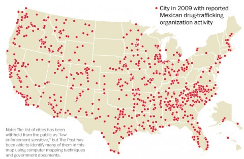
At least nine Mexican cartels are operating in the streets near you; in every Amercian city and most of the suburbs.
Their names are Sinaloa Cartel — the cartel of the infamous Joaquin “El Chapo” Guzman. Others include the Juarez Cartel, Los Zetas Cartel, Los Caballeros Templarios, Beltran-Leyva Organization (BLO), New Generation Jalisco, Los Cuinis, Gulf Cartel (Cartel Del Golfo)(CDG) and the Michoacan Family (La Familia Michoacana)(LFM).
Think thy’re not near you? Think again. Here’s a map complied by the Washington Post:
The Gangs
Not all criminal gangs are cartel orginated. Others have their own origins but work with the cartels in the distribution of drugs. Some worthy of comment:
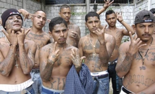
MS-13
MS-13 (Mara Salvatrucha) originated in Los Angeles in the 1980’s. Most members are Central American (mostly from El Salvador). This is a gang that formed in LA, but spread into Mexico and Central America and all across the United States.
From Wikipedia: “In the U.S., the MS-13 has an especially heavy presence in Los Angeles County and the San Francisco Bay Area in California; the Washington, D.C. metropolitan areas of Fairfax County, Virginia, Montgomery County, Maryland, and Prince George’s County, Maryland; Queens, New York; Long Island, New York; Newark, New Jersey, Plainfield, New Jersey; Jersey City, New Jersey; Elizabeth, New Jersey; the Boston, Massachusetts area; Charlotte, North Carolina; and Houston, Texas. There is also a presence of MS-13 in Toronto, Ontario, Canada.”
It is estimated that MS-13 has as many as 50,000 members worldwide, with as many as 10,000 in the United States.
These are some very bad boys. In addition to drug trafficing and wholesale murder, they get involved in human smuggling, child prostituion, arms trafficing, extortion, money laundering, kidnapping and a host of other felonies.

There are countless gangs in the United States besides MS-13; the Latin Kings, the Aryan Brotherhood, Barrio 18, the Bloods, the Mongols Motorcycle Gang, the Crips, the Mexican Mafia, and on and on and on. There are an estimated 30,000 gangs in the United States, and many, if not most have their fingers in the illegal drug trade.
Finally, it should be noted that these gangs are responsible for in excess of 2000 murders each year. Those concerned with gun deaths in America should take note that gang-related murders are the largest single cause of such deaths.
Will building a wall change anything?
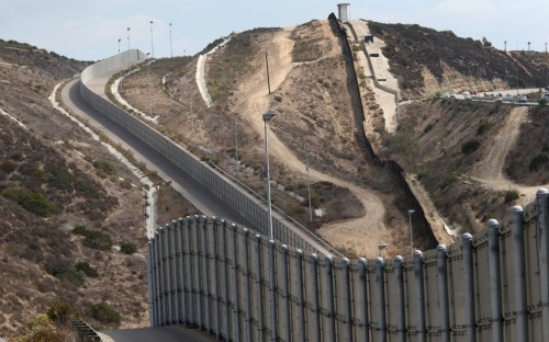
Critics, as expected, say “no”. To be sure, there are already sections of the border with physical boundries; some wall, and some fence. There is a ten foot high wall along a fourteen-mile section south of San Diego. Various starts and stops over the last two decades or so led to the creation of a bit over 600 miles of fence along the border. In some places, the fence abruptly just ends; making it simple to just walk around. Calling much of the existing barrier a joke would be an understatement.
There are also legal issues, as some of the border passes through privately owned land and Indian reservations. Previous attempts at eminent domain have been met with lengthy litigation. Additionally, there are environmental issues, terrain issues, and a host of other potential problems.
Discussions about type of barrier run from the sublime to the ridiculous. Below are some of the current types of fencing used on the border. Click on the image for a larger view:
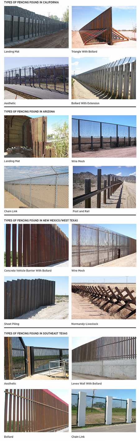
All of these have been penetrated; over, under, around or through. There is no easy answer here; nor an inexpensive one.
How much would it cost?
Estimates from supporters to critics run the gamut. It seems almost impossible to get accurate figures, based on the many variables, such as type of materials, size and a maze of terrain obstacles. Based on estimates running from MIT engineers to the Department of Homeland Security, it appears a practical cost would be between $20 and $30 billion dollars, plus millions more each year for maintainence. In addition, this would be a multi-year construction project.
Is it worth it?
Focusing only on crime and illegal drugs, would a wall reduce drug trafficing into the United States?
Critics argue that trafficers will find a way to get in regardless of barriers — they always have so far. But that begs the question. What they have surmounted to date is a hodge-podge of half-baked measures, not a completed security barrier.
If indeed illegal drugs cost Americans $200-300 billion per year in related criminal costs, a barrier that reduced that traffic by even ten percent would pay for itself almost immediately.
Reducing the amount of drugs coming into the country is only part of the problem — the supply portion. Demand is another issue altogether. It is possible to work on both sides of that equation, but only if the public is supportive and dedicated to it. The social aspects of building a wall are legitimate topics far beyond the scope of this article.
Building a wall may be practical or it may only be symbolic. The question is whether or not the American public wants to take on the issue of illegal drugs and the crime associated with it, or allow things to continue as they have.
1. Drug Trafficing from Mexico — FBI
2. Heroin Addication Costs US More Than $50 Billion/Year — Newsweek
3. Economic Impact of Illicit Drug Use on American Society — US Department of Justice
4. A Pre-History of Mexican Drug Violence